

By: Hannan Mohammed
Today, maps are used extensively in many forms: in paper maps and globes, and in satellite systems and in global positioning systems (GPS) as well, which we use as a tool to help us navigate. But, how did maps evolve into what they are today? And what were they originally?
Historians don’t know what the ‘earliest map’ is; while some believe that the earliest surviving map is a mammoth tusk with markings that depict the landscape of the area it was found in from 25,000 BCE and others have suggested that rock art paintings with constellations from 17,000 BCE found in France are the earliest known star maps, the earliest known maps were usually credited to the Babylonians around 2300 BCE. These ‘maps’ were clay tablets with details etched into them and usually used for land boundaries and planning agriculture.
Around 600 BCE, more world maps were created in Ancient Greece with major scientific advances, but with no measure of scale. One such example is the map that the Greek philosopher Anaximander created around 600 BCE, which represented the world as a circular disk surrounded by oceans. In 200 BCE, Claudius Ptolemy, a Greek-Egyptian scholar, created his work Geographia, outlining latitude and longitude for accurate navigation as well as mapping thousands of areas with coordinates. He was also the first to display the world on a two-dimensional surface, and thus he’s commonly credited as the creator of cartography, or the study of mapmaking.
During the Middle Ages, Muslim travelers and scholars developed cartography based on their own experiences and earlier Greek and Roman works. For example, the geographer Muhammad al-Idrisi created the most advanced map of its time in 1154, known as the Tabula Rogeriana (The Recreation of Him Who Wishes to Travel Through the Countries). It showed areas with great accuracy and included information about those areas, and this map was known as the standard of cartography for many years, used by travellers in the region.
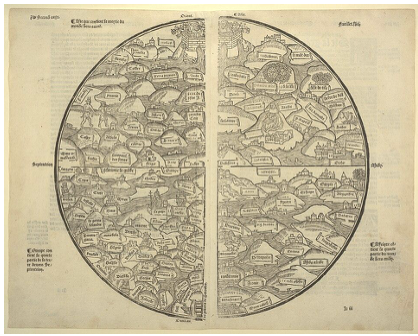
European maps, meanwhile, were created and used for educational and religious purposes rather than to be used for navigation. They were called Mappae Mundi, depicting landmasses and differences in climate. They were also heavily drawn from religious texts, and therefore many of these maps showed Jerusalem as the center.
As the Age of Exploration led to the discovery of lands in the Americas, existing maps were challenged. In 1569, Gerardus Mercator used these discoveries to create the Mercator Projection, a map still used today. It preserved the shape of landmasses while distorting size closer to the poles, allowing travellers to plan their journeys accurately by drawing a straight line to any point on it and using the direction of the line.
In the industrial revolution, mass-printing led to the production of smaller, more practical maps for tourism use, while maps were constantly being updated as transportation advanced further. In the 20th century, another major advancement was made with aerial photography and satellite imagery, allowing for greater detail even in obscure locations; one such satellite is Landsat, which was launched in the 1970s and produced real-time data on the Earth’s surface, again revolutionizing cartography with its greater degree of accuracy.
As computers and other devices have become more prevalent, cartography has advanced considerably in its accuracy, leading to us using maps more frequently than you might think: for example, you might use digital maps to navigate while you’re driving, or you might even create and share your own map to online platforms.
For more information, please visit:

